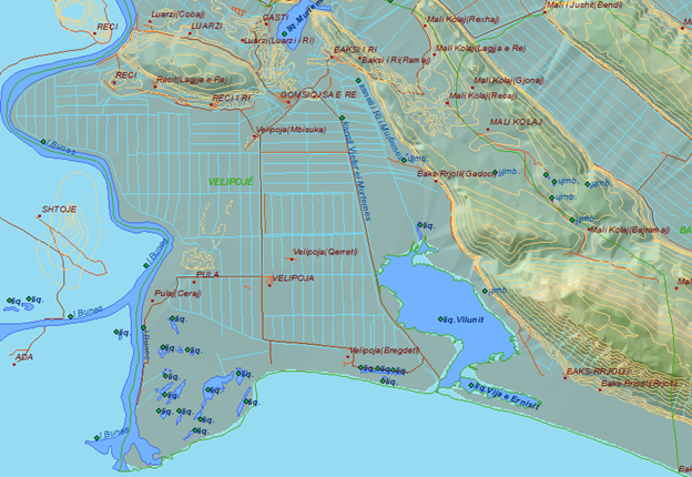
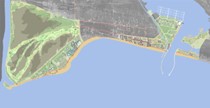
The municipality of Velipoja is part of the Shkodra district; it is located in the southwest of the city of Shkodra at a distance of about 24 km from it; in the west it is bordered by Montenegro along the Buna river, in the east by the Lezha district, in the north by the municipality of Dajç and to the south by the Adriatic Sea. The total area is 72.4 km 2 .
The extent of the coastal municipality of Velipoja and its constituent units.
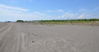
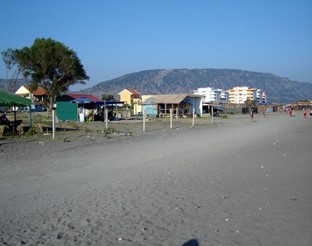
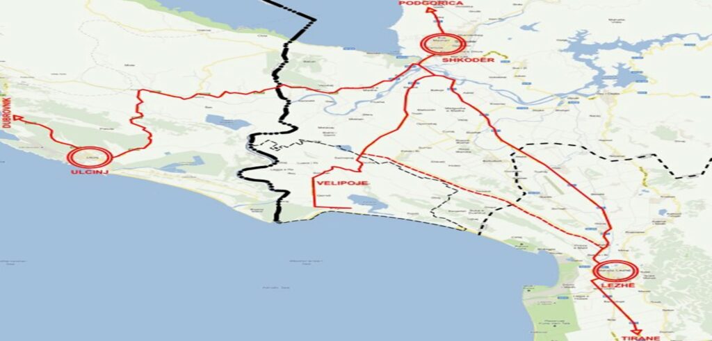
The number of the current population in the entire municipality of Velipoja is 9,417 inhabitants, while the density is 69 inhabitants/km 2 . The total length of municipal roads is 41.65 km, the length of paved roads is 26.4 km and the length of unpaved ones is 15.25 km.
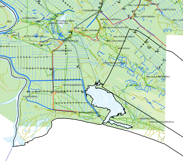
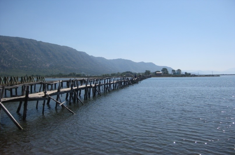
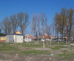
Laying down of roads in the municipality of Velipoja
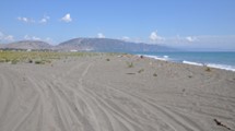
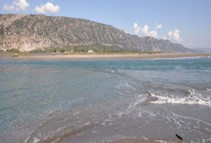
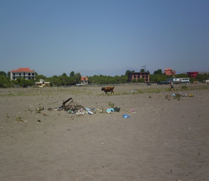
Velipoja beach has a length of 14.5 km. The stretch of the beach in a condition of such parameters creates numerous and inexhaustible opportunities for tourist use from the Buna river to the edge of the field of Zunkthi (or as it is called Rëra e Hedhur).
The waterfront takes somewhat different views from one segment to another. Thus, in the beach segment, it is less steep and calmer because this segment is near a low basin or field with a very small height. On the contrary, in the beach of Rana e Hedhun and in the delta of Buna, the face of the beach is steeper, which creates a greater depth of the water part of the beach.
Laying down of roads in the municipality of Velipoja
Viluni Lagoon
The lagoon of Viluni is located 2 km east of the beach of Velipoja, It covers an area of about 300 ha, up to 1m deep and only in small sectors up to 2-3 m. Surrounded by wetlands, it connects with the sea through a natural channel, in which, due to the ebb and flow, the water changes direction every 6 hours. There is salty water with an average temperature of 20 - 22 ºC in July, while in February the temperature reaches 5-7 ºC. It is rich in fish of various species and plenty of them are delicious. Also, there are many birds (183 species) migratory and permanent, reptiles and mammals: rabbit, fox, wolf, wild boar, etc.
All those who suffer from rheumatism have one more reason to choose the beach of Velipoja to spend the summer holidays.
Its iodine-rich sand is known for its curative powers. The Shkodra inhabitants consider it the sand of Derman (salvation). Even those who enjoy full health on this coast can find everything to spend an active vacation. The sand is extremely clean, rich in iodine.
If you go in the direction of the Buna spill you will see all the iodine spots as it is the area least used as far as the beach is concerned. In 2016, the water in the Velipoja area was certified as an
excellent quality water from the European Environment Organization.
On over 14 kilometers the beach cleanness attracts the tourists’ attention; the air has curative oxygen, or ozone O3 and impressive nature, hospitable people and vegetables and fruits that come from the yards of the local inhabitants, there is also the "black" sand, which is a closed brown sand.
The coast is covered with a layer of fine sand of a dark color, which is saturated with iodine,one of its healing ingredients.
To understand the reason for this color, which is related to the unusual concentration of iodine, it is necessary to consider that most of the seafront of Velipoja was, before the 1990-s, a wild area,
guarded as a military zone. The reason was the border proximity with Montenegro.
Sand bath is a genuine cure that fights arthritis and rheumatic ailments. While the iodine is from the sea, in the case of Velipoja, the concentrated iodine of the "black" sand heals all types of thyroid diseases, which are related to the lack of iodine in the body. This is very important, because iodine, although widespread, in order to create curative and healing effects must naturally be as concentrated as possible.
The protected landscape "Buna-Velipoja River"
- It covers an area of 23,027 ha. The length of the Buna river is about 44 km, while the fall is only 1.2 m/km.
- Latitude / 41° 43' 4” N
- Longitude / 19° 35' 56” E
The water/terrestrial protected landscape of the Buna River has a total area of 23 027 ha, consisting of:
- Latitude / 41° 43' 4” N
- Longitude / 19° 35' 56” E
- Latitude / 41° 43' 4” N
- Longitude / 19° 35' 56” E
- forest and scrub area - 7 799 ha
- lagoon area - 346 ha; coastal sand dunes, - 496 ha
- saline lands - 252 ha
- other areas (agricultural land, residential areas) - 14 134 ha
The central area
The part of the Buna River and its banks from the confluence with the Drin River to the village of Obot; the banks of the Buna River in the western part of the Velipoja reserve, from the mouth of the river to the northern end of Ada Island and 200 m inside the reserve to the east; Franz Josef Island and the coast to the east of the estuary, up to 2 km long and 300 m wide in the sea, towards the south; the central and northern part of the Vilun lagoon; the peninsula on the beach of Baks-Rrjolli and a width of 300 m in the South of the coastline up to Rëra e Hedhur; the central part of the marshes of Domni and Murtemza.
The sector of the Buna estuary
The central sector of the coast of Velipoja
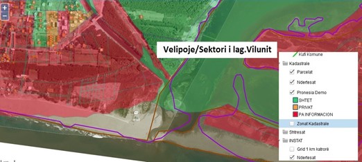
Viluni lagoon sector
Vegetation and Flora
The flora is very rich. It is worth mentioning populus, salix, pinus, fraxinus, alnus, paliurus, nimphea alba phragmites, juncus etc. An honorary mention to a rare species, Querqus robur, which is in danger of extinction.
Forest vegetation in the literal sense can be found on the banks of the river in the Velipoja Reserve, the islands of Ada and Franc Jozef, in the villages of Reç, Sutjel, Shënkoll and on the island of Bahçallek. The vegetation of these forest areas mainly consists of several types of poplars, willows, ash trees, oaks, as well as gooseberry, acacia, sedge, scotch, sea buckthorn, etc.
Climate
- The climate is lowland Mediterranean
- Average annual air temperature - 16ºC - 18ºC
- Average annual rainfall - 1600-1800 mm.
- The area has 280-300 sunny days per year.
Important habitats
- The mouth of the Buna River
- Coastal lagoons (Velipoja, Viluni, Martenza, GjoLulit)
- Coastal dune with Juniperus oxycedrus subsp. Macrocarpa
- Coastal forests of sand dunes with Pinus halepensis, P. pinea, P.pinaster
Fauna of the "Buna-Velipoja River" area
The Buna river, the Velipoja reserve, the Domni marsh and the Vilun lagoon are full of birds.
Number of species and individuals:
The largest number of species is 47. The largest number of species’ individuals: Fulica atra (1089) and Larus ridibundus (319).
Species status according to IUCN:
The status according to IUCN 2015 of bird species counted during 2004 – 2015 (winter aspect) in the Buna River Protected Area (Albania) is 59 species (out of a total of 61 species). species of fauna with national status and 36 species of fauna with global status (Viluni Lagoon).
The wetland is a refuge for migratory seabirds and attracts many species of birds such as Red-headed, Duck, Bajzat, Kredharak, Karabullaku, Cafka . The area is also an important feeding and migration habitat for Dalmatian pelicans.
Many wild animals live in the forest: rabbit, jackal, wild boar, pheasant, etc.
VERTEBRATES
At the mouth of the Buna River, at a depth of up to 40 m in the sea, 66 species of fish have been found.
The most dominant species: Mullus barbatus mullet, Merluçuis merluçius cod, Spicara smaris maridha, Citharus linguatula paroshja, Lepidotrigla cavillone scaly cocklefish, Solea solea Tongue, Torpedo electric fish torpedo.
There are 8 species of fish that develop biological migrations in the routes Adriatic Sea ↔ Buna River + Lake Shkodra. Mugil cephalus the summer eel, Liza ramado the autumn eel, Anguilla anguilla the eel and Alosa fallax the migratory kubla are important species for fishing. Tursiops truncatus The bottlenose dolphin prefers sea shores and river deltas. In the prodelta of the Buna River, 8 such dolphins have been seen, while 12 such dolphins have been seen along the river, in the warm seasons.
Caretta caretta is the sea turtle found in the Buna River near Muriqan. This species of turtle comes to the sandy shores of the sea to deposit its eggs, but this case is rare in the Buna River, 7 km near Shkodra.
Ursus arctos The brown bear has been found in the forest of Maja e Zeze
Territorial characteristics of the space of the municipality of Velipojë - development plans and information
The dynamic and chaotic developments of the territory in this space turned out to be informal in most cases after the 1990s, which brought about increasing social problems that in many cases still exist today as a legacy. In this vortex, in the biggest and fastest scattering are the beaches of Velipoja, which before the 1990s had only a few cabins and 3 hotels.
In the early 1990s, an influx of construction (light construction) for commercial purposes began.
This spread of constructions without a plan and outside of any criteria resulted in the loss or mismanagement of agricultural lands in the municipality of Velipoja. This was a chain process; therefore, each owner acted in the same way. With the exception of a few cases in the village of Pulaj, there has been no return of property to the former owners around the beach area.
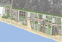
Evolution and partial urban plans for the municipality of Velipoja
Between urban plans and "dominant" informality
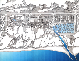
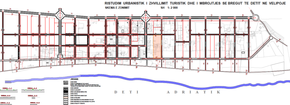
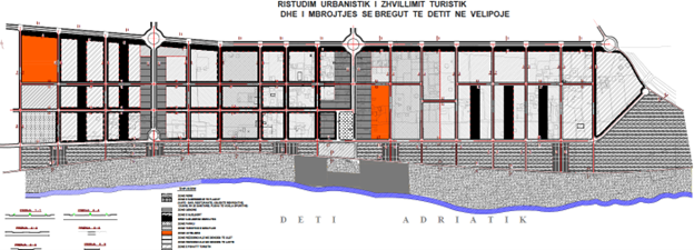
In 1995, a master plan drawn up by an Italian studio was approved that envisioned the beach of Velipoja - a beach of quality tourism, with spaces for tourist villages and architecture in accordance with the environment ; Urban planning study and construction site for a tourist village in Velipojë with an area of 8.5 ha, approved by KRRTRSH, decision no. 8 dated 16.09.2000;
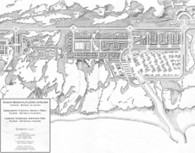
Urban planning study for the tourist development and protection of the Velipojë tourist area, approved by Decision No. 1 date. 18.06.2003 by KRRTRSH;
Another urban plan has been prepared by the Institute of Design Studies, which takes into consideration the constructions made, but which is not approved by KRRTRSH.
Partial urban planning project of 1995 / Velipojë Municipality by Tullio Zinni
Urban re-study of tourism development and protection of the sea coast in Velipojë (Source: ISPU, 2003)
The great thirst during the years of economic uncertainty and freedom of movement 1990-2000, led to mass occupation of state and private lands, especially in the coastal area of Velipoja .
Construction was done without regard to zoning or building laws, without permission from official authorities, without proper infrastructure and, often (but not always), on land that did not belong to the builders. The lack of effective construction planning and control enabled the construction of many buildings out of all norms. They are now considered illegal. As a result, a significant number of properties remain outside the formal real estate market, and illegally built structures not covered by the legalization process continue to be exposed to the risk of demolition.
Photos above: informal constructions
According to a calculation made, in the municipality of Velipoja there are about 2000 constructions without permission (1253 in the legalization process), concentrated in the beach area as well as along the Viluni road. These are chaotic constructions and not in architectural harmony. They are generally from 1 to 5 floors. The abandonment of urban development of the beach within the existing master plan area to market forces has caused the development of the area to fall far short of management and replanning in accordance with the principles of sustainable development.
The abandonment of urban development of the beach within the existing master plan area in the hands of market forces has caused the development of the area to be far from being managed and re-planned in accordance with the principles of sustainable development.
In the same way, the frenetic constructions outside of any sewage or white water capacity, their discharge into septic tanks or even directly into the sea in some points of the coastline, has seriously damaged the quality of the cleanliness of the sea and the sand in the coastal area of Velipoja. Above all, we emphasize that these pollutions that are deposited underground, as ecology specialists point out today, can also affect the underground water table and from there they risk infecting, as various leaders of local administrations warn in their reports, all the elements of the eco-system, without avoiding the risk of permanent infection in this area in the future .
The issue of ownership and extreme fragmentation of land
Public property without inventory in this coastal municipality has often been treated as private property, bypassing all laws and norms. Although the registration process has been started for 18 years, it is still not finished, and hundreds of decisions have been produced for the inventory and transfer of public property, to the local government or other public institutions, but in most cases they have deficiencies related to the information cartographic, which even in cases where it is not missing, is incorrect.
The extreme fragmentation of the land in the municipality of Velipoja and the lack of data on the types and categories of the land makes it difficult to develop the territory, hinders investments in construction and tourism, and in many cases the impact it can bring on the environment remains to be assessed. The lack of a unique cartographic standard, the use of different cartographic bases by different institutions, is a problem that requires urgent measures, because it not only fictitiously increases the problems of overlapping properties but also produces conflicts of a legal and administrative nature.
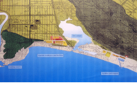
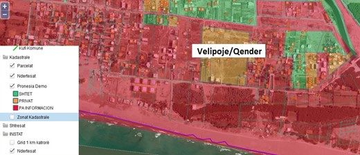
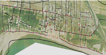
Ownership plan Velipojë sector/Beach center (Source: ASIG, 2014)
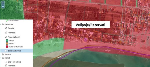
Ownership plan Velipojë sector/Viluni lagoon (Source: ASIG, 2014)
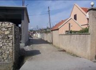
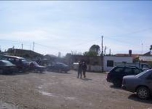
The intervention in the road network of the municipality has become necessary, due to the fact that the roads are not asphalted and paved with gravel. This intervention would increase economic activity and improve life.
Uncontrolled constructions and the lack of implementation of the beach development plan have made the access roads to the beach as well as the internal roads that connect the center of the beach or the national road with the hotels difficult to pass and maintain. Therefore, it can be said that the road network of communication in the beach area is missing, the internal roads are partially destroyed and on rainy days they become almost impassable.
Regarding the white and the wastewater system, the water supply for the municipality of Velipojë is made from the village of Trush, from a distance of 12 km. The water supply network has a pump system with mechanical lifting, a storage system and a free flow system.
There are no waste water sewers in the municipality of Velipoja. In the entire municipality, septic tanks are used, according to their worst model, and their number is almost equal to the number of houses. Each household collects wastewater in individual septic tanks. Families living in buildings (Ças: 12 buildings, Reç i Ri: 13 buildings and Velipoja 10 buildings) have centralized septic tank systems. In these environments, sewage erupts and flows along the road, posing a risk for the spread of infectious diseases. This "solution" is outside of all standards and poses a risk to groundwater and the beach area.
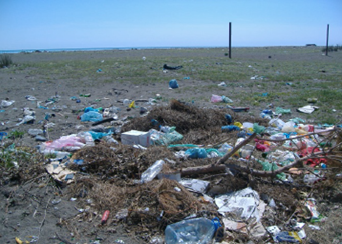
Another problem is the issue of urban waste. Even though the municipality declares that it covers 100% of the waste area with regular service (daily waste collection) and that it has covered most of the PGMs of the urban area, there are still shortcomings with the waste infrastructure. In the waste area, there is an insufficient number of bins and piles of waste are dumped on the ground, mainly around the bins or on damaged points.
It is necessary to organize a regular cleaning service (every day in the central area and less frequently in other areas) during the summer season (June - September).
Here, too, near the roads and the green area, the placement of small street bins is required to collect waste every day.
Arrangement of collection points
Orientation of the Velipoja space from a peripheral area to a functional zoning
The fragmentation and "mushrooming" of the coast of Velipoja with spontaneous or individual constructions seriously damages and asphyxiates the potential of its development. A new administrative-territorial division would be an instrument to orient this space from a peripheral area with seasonal use, towards a functional urban area, based on the trinomial of geographic space-population-economic development of the territory.
In this sense, "Velipoja functional area" will be the administrative unit organized around an urban center like Shkodra that has the highest number of population, compared to other centers within the area, and has the opportunity to provide the full range of public services that must provide a local unit .
The coastal area of Velipoja, connected to the city of Shkodra, is of particular interest both in terms of its content, function and decision-making capacity over the territory, as well as from a visual point of view for the best possible completion of the city's panorama.
In the new functional area of Shkodra, where Velipoja is supposed to be included, it will be possible to give the necessary priority to the roads connecting the municipalities with the administrative center, enabling a reduction in travel time.
Of course, the development of the infrastructure of the region of Shkodra will be planned in harmony with the national infrastructural development and, more broadly, with the international one. Also in the focus of the new development will be the increase in investments in the water supply infrastructure and sewerage and sewage system.